Indonesian Coastal Fisheries

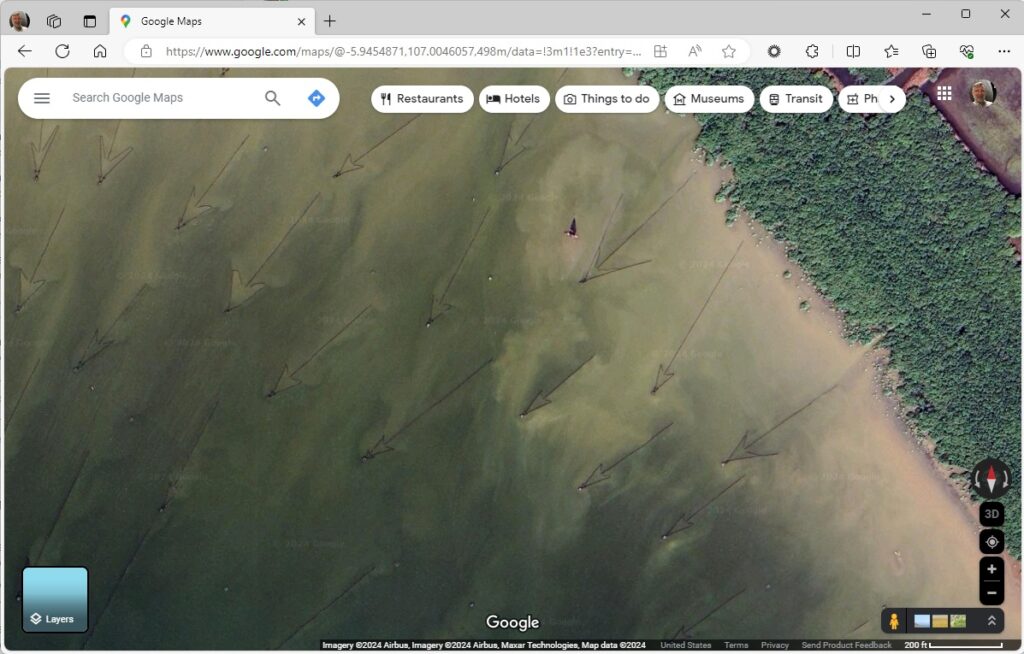
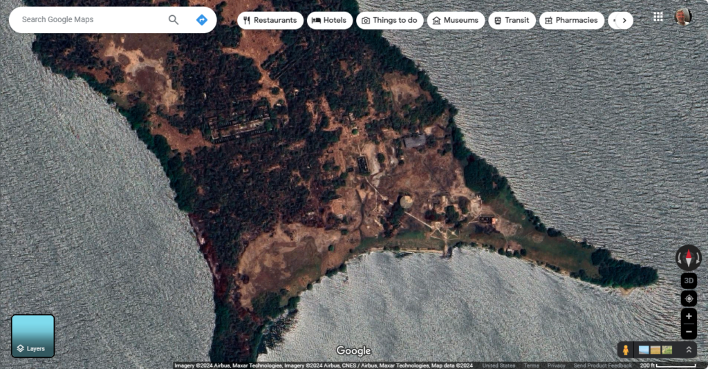
Go southwest, or so the arrows seem to suggest. What do the arrows point to? Jakarta, on the island of Java, in the Java Sea, but that’s merely coincidental. This is an area where mangrove roots nurture and protect all sorts of aquatic life. So, the big fish work their way into the mangrove forest for a snack during high tide, and then swim back out to the ocean. But then they run into these long fences made of bamboo as they travel back out to sea and follow the fence into the point of the arrow. A little hut is built at the very tippy point of the arrow where the fish will concentrate as they try to make it back out to sea. And then, somehow with nets or a collapsible fence, they haul in the fish.

BUT WHAT ARE THE IMPLICATIONS TO WORLD BUILDING? Ecology, and a culture built on a fishery. Enterprising people develop ways to make life easier for themselves. Each one of these little arrows (I could imagine) would be maintained by a family or several families. Fishing is also a group effort.

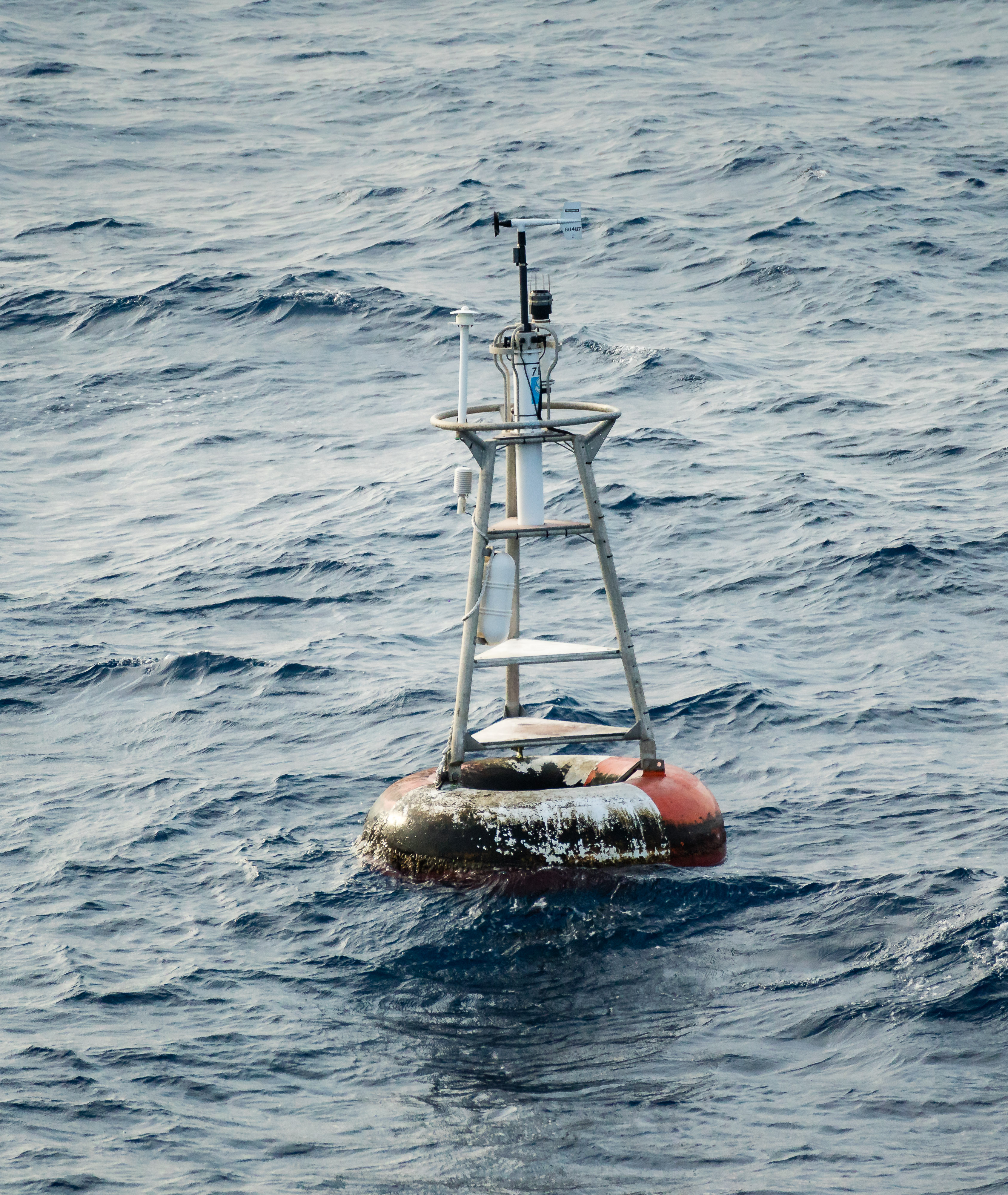
{null} Island

Graham Curran, CC BY-SA 4.0 <https://creativecommons.org/licenses/by-sa/4.0>, via Wikimedia Commons

This is the most magical place on earth. At least, from a geographer’s standpoint. This is where the Prime Meridian meets the Equator off the shore of Africa in the Atlantic Ocean. It’s not an island, it’s a weather buoy.

Maybe it isn’t all that magical, really. The coordinates here are (0,0) using a standard geographic coordinate system with latitude and longitude. A geographical coordinate system uses a spherical model of the earth. It is often very useful to pretend the earth is flat. Well…. not the whole earth, obviously, but a little rectangle of the world. Doing so allows geographers to better preserve distance between points (lines of longitude are further apart at the equator) and area calculations. We use a whole series of projected coordinate systems (Texas has five) to correctly model small parts of the world in a two-dimensional space.

When geographic data bounces back and forth between projected and geographic coordinate systems, inevitably there will be problems. Such as one system wants to store coordinates as text (33°00’00.0″N, 96°00’00.0″W) and the other wants numerical (22,000, 3,600,000) Trying to cram text into numerical fields never works, and when it fails, you are left with (null, null) which most mapping applications assume is (0,0) … and helpfully plot your location off the coast of Africa, here at Null Island.

BUT WHAT ARE THE IMPLICATIONS TO WORLD BUILDING? Location, mapping, navigation, exploration, cartography… Characters on a journey need to keep track of their bearing to keep from getting lost, and they need to be able to estimate distances between points especially if they’ve never made the journey before. Separate cultures may use different units of measurement, different points of reference–there might be other royal observatories in places other than Greenwich.

Hawthorne Army Depot

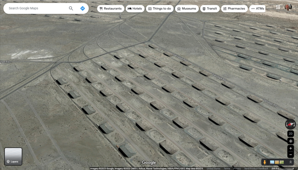
In deserts of rural, western Nevada, by the city of Hawthorne is the army depot. It’s where munitions are manufactured, but more importantly stored in these little isolated bunkers. Armies all over the world store munitions in similar fashion. I had believed that humidity might play into the life expectancy of munitions, and if that’s true, these bombs will be safe from corrosion for a very long time. Or perhaps the U.S government does not need to spend money on climate-controlled storage. The bunkers are equidistantly spaced, so that if there’s a mishap in one, it doesn’t cascade into all your weapons crates, burning up all your rockets, and making one giant crater.

These bunkers are concrete, with a concrete front, and sand is piled atop them. Native vegetation often grows over the bunkers, as we see in this image. What I find interesting in this site is that not only is each bunker serviced by a road, but the curving arcs toward the top of the image indicate rails. We can move weapons across the country by either transportation method.

Irrigating Grace, Idaho


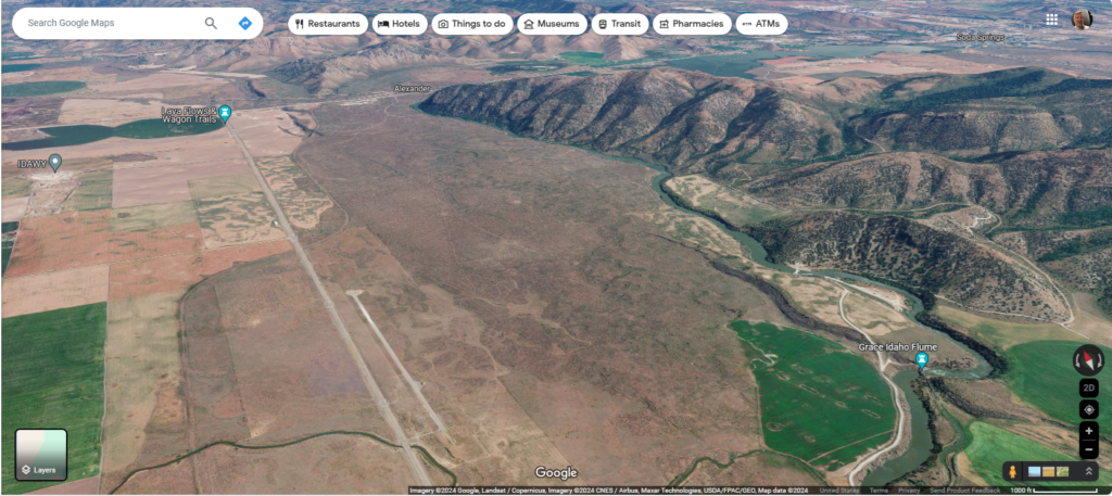
“Niter Ice Cave,” “Last Chance Canal,” and the town of “Grace” are all associated with Gem Valley on the Bear River in southern Idaho. The ice cave formed at the edge of a lava flow (I don’t know how–that’s not important right now,) Last Chance Canal refers to the desperate struggle to irrigate crops in the fertile valley before the land owner’s water rights expired, and “Grace” is the name of the Mormon community that flourished as a result.

In this fantastic image, the Bear River flows into Gem Valley from the top right corner, but instead of filling the valley with wholesome, hydrological goodness, the river appears to have been interrupted by a lava flow that fills the central third of the image. Crops on the left, mountains on the right, and igneous rock down the middle. And so, the water flows between the mountains and lava, doing nobody any good.

However, the height differential creates a unique opportunity for irrigation: if you can dig through old igneous formations carefully, you can irrigate the whole valley. The Last Chance Canal Company accomplished their goal, and added a bit of hydroelectric power into the deal as well. Last Chance Canal Historical Marker (hmdb.org)

Scars of Magic

By Matthew Devine

Magic entered the world and violently marked the landscape. Not only did the elders tell the tales to children as they sat around the fires at night, but some of the people could feel magic. A gentle tug, some claimed, an affinity for one of the primal humors. Those attuned to the humors knew.

There once was a world, peaceful and serene, untainted by magic and spirits, but when they arrived, spirits of fire warred against spirits of water. Mountains were formed and canyons were carved. Spirits of air, quiet, patient, and invisible, did not get involved in the squabble, but they spirits were nonetheless involved in shaping the world. Together, these formed the primal humors of magic.

Jarek knew.

Some called it a blessing, some called it a curse, but there were only a few from the clan in each generation capable of feeling magic, and fewer still that could influence it. His great aunt had been one; a water witch, they called her. She could swim as fast a man could jog. But that was the extent of her ability. It was called a curse. Bree’nel the Sleeper had been dead for a decade, but he could cause clouds to form and make rain. Afterward, he slept for days at a time. It was called a blessing.

The attuned had a primary alignment to one of the humors, but they could feel others as well; Bree’nel knew air almost as intimately as he knew water, it was said. Jarek’s aunt spoke with familiarity of things under the land, and she could feel fire in unnatural ways. She spoke of nonsensical things too… ergo the curse.

Although in recent memory, people had been influenced by the gentle spirits of water, the stories recorded men who could immolate themselves at will or cause a fire to burn without spark, ember, or tinder: all demonstrations of a curse.
When a person died and the land received the dead, the tribe quickly moved on, carrying the memories of the deceased with them, and nothing else. Too many dead in one place could anger the land again and provoke the spirit of death.

“Aunt Tikka was not crazy,” Jarek said. He shifted his pack and continued walking uphill.

“Like hell she was. You didn’t know her.” His father mumbled behind him. “Elders told the story of the moon on the eve of the hunt, and she corrected them. You don’t interrupt the stories, and you don’t corrupt them. She knew better; she was crazy. And you never heard her talking about switching places with her shadow.”

Jarek had visions of a land with an orange sun; dimmer, larger, and well… plain different. Plants were huge and their leaves so dark a green as to be almost black, absorbing every ounce of light that might otherwise reach the ground. Was he crazy too?

Father continued. “When she realized it, she stopped acting out, stopped saying crazy things. But you don’t forget that stuff.” The shuffle behind Jarek stopped. “You don’t see unnatural things, do you, son?”

Jarek turned around. “Of course not,” he said.

“Then why are you dragging me up this mountain? There were sheep and deer on other mountains close to camp. We’ve been traveling for days, I’m tired, and I know you better than that. You are following a pull.” Father kicked rocks aside and sat on the hillside.

Jarek sat next to him, opened his pack, and handed his father a slab of dried venison before drinking from his own waterskin.

Father nodded his thanks. “You think me a daft old man. You’ve planned for weeks, I watched you.” He chewed venison, staring at Jarek.

Where water flowed powerfully, the humors were stronger. Waterfalls, where the river bent, and where it tumbled powerfully over rocks; Tika had said so, and Jarek had felt it for himself, though he was not attuned to water. He also knew when he approached forgotten, ancient graves, but he told no one; the stories of necromancers were so grim, they were only told to older children and never at night. He felt a low, distant rumble, a churn like a snoring old man sleeping nearby belonging to the dormant but explosive spirits of the mountains, or so the stories told. There were places in the forest where vegetation grew dense and the humors healed both body and mind, albeit slowly. There were stories of healers with abilities beyond herbalists, healers attuned to life who could even regrow limbs.

Even if people were not attuned to humors, they could still see the evidence of old magic on the land.

“You feel a pull too,” Jarek said, his father shook his head.

“Tonight is a full moon,” the old man replied. “Am I going to be surprised?” He lay down, closing his eyes.

“You feel it,” Jarek insisted. “We can’t rest yet.”

The big humors were easily visible: fire, water, and air, mountains, rivers, and windswept landscapes. Many lesser humors existed, so abstract that they were unknown; the humors of life and death being the only exception. Tikka’s shadows had been a vesture of a lesser humor, Jarek’s visions were likely another.

“I’ve seen crazy,son. I’ll tell your story when I return home.”

“That’s comforting,” Jarek replied dismissively. He extended his hands and helped his father up. Both men groaned.They settled their gear and continued up the slope of the barren mountain.

The pull was strong, irresistible. Jarek was certain his father was sensitive; the nearer they were to the source, the more energy both men had. Toward evening, Jarek reached the scar on the land; it had been summoning him for months. If Jarek could fly, from above the valley, the scar would look like a pile of rocks in the center of a spiral path made from the same stone; a continuous, arcing path radiating outward with unnatural symmetry and precision. Beneath the soil, the spiral continued—hidden—some distance from the pile. Jarek could feel where it began far from the central pile of stones, and he walked to the edge of the spiral, careful not to tread in the invisible troughs; only on the buried stone path.

“Jarek? What is it?” Jarek’s father stood, mouth open, silhouetted against the rising moon.

Jarek didn’t answer. He ran. Feeling the pull of the stones beneath the soil, he ran along the buried path. He continued to run along the path as it rose from the soil, following the spiral to the central pile of rocks. It was still distant, and the spiral path was long. It never crossed his mind to jump across the troughs, to take a shortcut to the center.

“Jarek!” his father called from outside the buried path.

Another step. Behind Jarek’s father, the moon turned orange. It was large and bright. When Jarek touched the central pile of stones, it changed subtly. The rocks became sharper, the path taller and completely revealed to him, and just beyond the spiraled path, dense green vegetation grew in the moonlight where his father had once stood.
Grasberg Mine, Indonesia

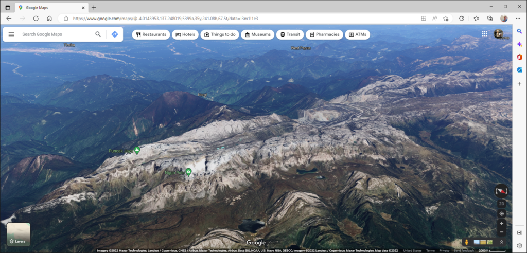
Grasberg mine is located near one of the tallest mountains on earth: Puncak Jaya or Carstenz Pyramid–one of the Seven Summits. Copper deposits near the peak were discovered by a geologist on a climbing expedition in 1936. In the image, the mountain peaks are to the left, and Grasberg open pit mine is to the right of center. It looks like an eye here, but from a top-down aspect, it appears more like a bullseye with concentric rings leading downward into a pit; the rings being roads that trucks use to transport ore up from the center of the mine. The ore from Grasberg is primarily copper, with gold and silver being secondary and tertiary products.

As with all mining operations, there are significant ecological considerations, such as heavy metals contaminating runoff, high acidity of the runoff, and excessively turbid water. As a result, native fish have all but disappeared from the rivers.

One of the things that I find amazing about this place is obviously the elevation–there are glaciers nearby–but what I find incredible is how much work it took to build the infrastructure in such a remote place and the logistics to continue operation. How well do gasoline engines run at this altitude? Where do the employees live? How does the ore get to a port or refinery, and how can it all be operated in an environmentally responsible manner?

The Palo Duro Canyon

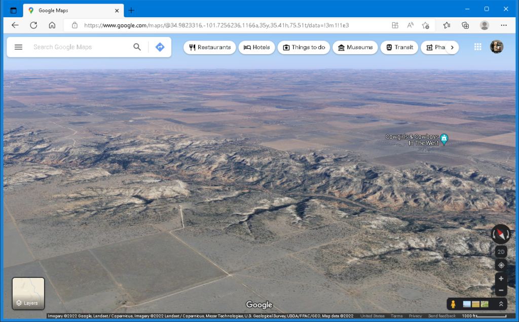
Screenshot of Google Maps looking northward over the rim of the Palo Duro Canyon

The high plains of Texas (or the Llano Estacado) are flat, semi-arid, and the view is not even broken by trees. But there is a really big ditch–the Palo Duro canyon.
How does such a landform impact the surrounding environment? There may be water flowing along a canyon floor, or pools of an ephemeral stream. If not, the water table is closer to the surface.

Either way, there is more vegetation, and a greater diversity of vegetation. The land may support trees that provide shade for mammals and nesting habitats for birds. Wildlife will congregate there for shelter and water.

It is where hunters find game and trappers find pelts.

Getting to the bottom of the Palo Duro canyon is not terribly difficult, nor is it as simple as walking to the supermarket but building a road through this terrain (and a bridge at the bottom) is expensive. Switchbacks will be involved, making the road longer, and still there will need to be accommodations–fill and culverts–for rough, sloping terrain and drainage.

Until a road is built through a canyon, commerce on either rim will be affected. Bulk transport will be unavailable.

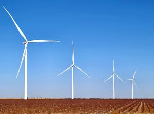
And let us not forget the wind. The bluebonnet is the state flower of Texas, but the wind turbine might as well be the state tree. At the bottom of the canyon there may not be much wind, but it will be a different experience on the rim.

Mercy Seven

By Matthew Devine

4237.175 TSE, 0735 LRT
Commander Honeycutt lay on the lumpy floor of his prefab, stretching. Wind warped the plastifoam walls, and the lightweight canvas ply roof thumped rhythmically against the support struts. As it had done all night. He had not slept well in days, and his face looked haggard even to him. After the bed deflated and retracted, he shaved, dressed, and stood in the center of his command center that had been unfolded on a plot of soil four square.

“Enable lighting profile. Enable environmental acoustic dampening,” Honeycutt said. Interior lights intensified and followed him as he reached for his term screen set on a table that unfolded from the wall.

“Open V-LOG, timestamp, and tag location.” Honeycutt called into the empty room and began scrolling along several feeds on his screen. “Commander Honeycutt, Expeditionary Force 457. Planet Mercy Seven, site seven, day three. Reference coordinates in mission brief. Sync log on scheduled interval or upon closure. Break.”

Why was this so difficult? On Honeycutt’s table, A motograph of Maire smiled, blew a kiss, and twirled in her white dress. The images had been captured on their wedding day, when they had married aboard Copernicus five years ago, but the backdrop was a spliced image of snow-capped mountains from earth.

“Open comm to Ecology,” Honeycutt said.

Sargent Nixx answered. “Reporting, sir. One moment, please.”

Honeycutt lay the motograph frame on its face, and a hologram emerged, Maire, dancing on the back. He switched it off.

When visual communication was established, a hasty, lumpy ponytail swished over Nixx’s shoulder. She wore a wrinkled, faded blue jumpsuit. Her smile was almost contagious.

“Reporting, sir,” Nixx repeated, her voice giddy.

“Is there a chance you have something other than amino paste for breakfast?”

“Negative sir, but I have not completed all my analyses yet. Site three will have a season of grain and had several endemic tubers that could be cultured. K-value was over eleven-three! I still cannot believe we are standing on a T-Type planet.”

“It does not seem real,” Honeycutt said. “Sargent Winters?” Honeycutt asked, Nixx blushed.

“Reporting, sir.” He emerged from the lenticular shadow in one corner of Nixx’s prefab and slid next to her awkwardly, the distance between them, forced. He had missed a button on his own rumpled jumpsuit.

“Since you must be helping Nixx with her reports, I take it the seismology evaluations are complete?” Honeycutt asked; they both squirmed.

“Negative sir. I am a day behind. The plasma corer broke again, and my team is working with tech to repair it. Moisture is such a problem. We expect to position it this afternoon and nurse it through the evening. I expect to be back on track tomorrow.”

“Preliminaries?” Honeycutt asked. Nixx and Winters glanced toward each other.

“I expect an overall K-value of this site—adjusted—between four and five,” Nixx reached for her pad. “Closer to four. It will support a very low-density population.” Nixx glanced toward Winters.

“But the views are staggering,” Winters said. “We’ve only scratched the surface…”

“You’ve mentioned already,” Nixx chided with a grin.

Unprofessionalism ran rampant among Honeycutt’s crew since the discovery, but he resolved to address it only if it became a problem. Members of his expedition were the first to set foot on active soil. No other living human had smelled mold or had tasted unrecycled water. They were the first in many generations to see vistas unhindered by the visor of an exo.

Winters nearly suppressed a smile and continued. “My team has never seen so many rocks. We are experts regarding a thing we’ve never truly studied. Before Mercy Seven, we’ve only seen fist-sized chunks retrieved by a sampler, and those had already eroded countless times by uncertain processes. Boulders. Mountains. I have a fine team, but they can get distracted.”

Yes, the entire chain of command was distracted, and Honeycutt was not immune.

“Astro was finished a decade before we arrived, Atmo is complete except for monitoring, and Ecology is on target. Winters, I need to know we are not sitting on a planetary cataclysm when I submit my report. Honeycutt over.” The image projected on the wall disappeared.

Honeycutt turned the motograph on; his holographic wife danced for a cycle, and he turned it off again.

“V-LOG resume. I have approved FTL transfer of the cargo pod aboard Copernicus to site seven of Mercy Seven. I spent my entire commission to fund the delivery, and I will probably die a pauper. But I filled my lungs with planetary air. Only members of expedition 457 can boast of that. Break”

Honeycutt donned thermals, put on his boots, and stepped outside in the morning chill. He held his breath. Temperature variance aboard his craft indicated a potentially catastrophic system failure; the substance of nightmares. The next generation would adapt to a variable climate naturally, and maybe in time he would too.

He walked across the rocky terrain, kicking stones ahead of him. Some were darker, some had streaks. Limestone, Winters had said. It was all so foreign to Honeycutt too. A plant with rigid leaves ended in barbs; clumps of brittle, brown, fine-bladed vegetation were immediately recognizable as grass, like some of the hydroponic produce aboard Copernicus. Nixx saw miracles of life and taxonomic relationships; Honeycutt saw extremes.

Arriving at the nearest atmo station, he checked power and communication functions, and continued walking along the rim of the basin wherein they had raised their prefab camp.

What would Maire think of this planet? She loved people. She was not a collector of prizes. Would she be inspired by the scent of rain? Or the dust and sun that scoured unprotected skin? He did not think so.

He checked the other atmo stations set up around their camp before returning to his prefab.

“V-LOG resume. I have petitioned the council to name this planet. Certainly, a million others have done so as well, but as commander of the discovery expedition, mine should be among the first. And I am commander—perhaps that lends weight. However, I am not a politician. I am impoverished even among the destitute if that ever meant anything.”

Honeycutt turned on the motograph. Maire blew him a kiss and danced. Math involving distances was difficult, but he had performed the calculations by hand the moment his expedition had arrived. She was nearly two centuries old now. She would be the first in many generations to be buried beneath soil, among the majestic peaks of a habitable planet that would hopefully bear her name.

“Break.”

Chutkotka Gulag

Paste these coordinates in Google Maps: 69.7405731, 171.8593084 Again, hold the shift key to tilt your view if you want, and be sure to expand the Explore imagery button at the bottom right.
Here we find a community built on a mountain above the arctic circle. There is no wood, no peat, no coal, oil, nor heat. But there is uranium in these hills, gold, tin, and other metals.

There’s really nothing good to say about this. Thousands of people died here, and for many reasons. One being that they were trying to survive in stone buildings built atop mountains in permafrost.
For more info, see Gulag of Chukotka, Russia (azattyk.org)

Tags: Government, Geology, Geography, I Have The High Ground Anakin

Lesotho: One country surrounded by another

I am addicted to maps.google.com. If you sign in, you can hold the shift key to tilt the map, giving you the ability to see elevation.

Here is an isometric aerial view of Lesotho; the boundaries are evident. It is set on a high plateau and carved with deep ravines. The tan and brown mountainous regions in the center and toward the back are Lesotho, and the green, relatively gentle terrain toward the front of the image is South Africa.

The oversimplified version: the people of Lesotho originally fled from the rising Zulu nation and defended themselves as the primary push of the Zulu was northward. Things stabilized somewhat until the French-supported Dutch (the Boer republic) on Lesotho’s doorstep encroached on their lands. A tussle ensued (Boer wars) and Lesotho emerged as a British protectorate (1868), and its own sovereign nation in 1966.

Tags: Geography, Geology, I Have The High Ground Anakin