Indonesian Coastal Fisheries

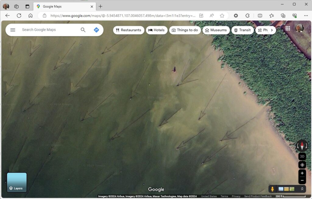
Go southwest, or so the arrows seem to suggest. What do the arrows point to? Jakarta, on the island of Java, in the Java Sea, but that’s merely coincidental. This is an area where mangrove roots nurture and protect all sorts of aquatic life. So, the big fish work their way into the mangrove forest for a snack during high tide, and then swim back out to the ocean. But then they run into these long fences made of bamboo as they travel back out to sea and follow the fence into the point of the arrow. A little hut is built at the very tippy point of the arrow where the fish will concentrate as they try to make it back out to sea. And then, somehow with nets or a collapsible fence, they haul in the fish.

BUT WHAT ARE THE IMPLICATIONS TO WORLD BUILDING? Ecology, and a culture built on a fishery. Enterprising people develop ways to make life easier for themselves. Each one of these little arrows (I could imagine) would be maintained by a family or several families. Fishing is also a group effort.

{null} Island

Graham Curran, CC BY-SA 4.0 <https://creativecommons.org/licenses/by-sa/4.0>, via Wikimedia Commons

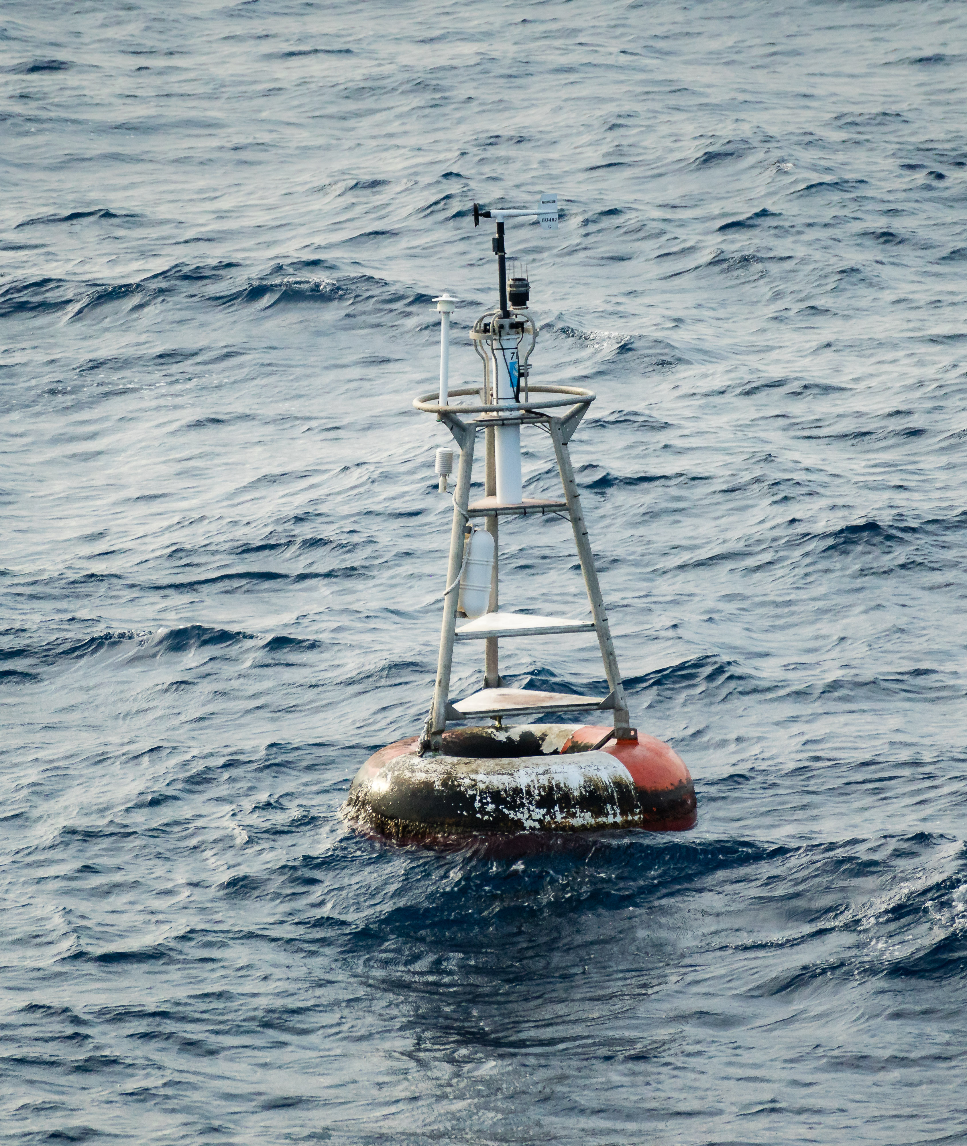
This is the most magical place on earth. At least, from a geographer’s standpoint. This is where the Prime Meridian meets the Equator off the shore of Africa in the Atlantic Ocean. It’s not an island, it’s a weather buoy.

Maybe it isn’t all that magical, really. The coordinates here are (0,0) using a standard geographic coordinate system with latitude and longitude. A geographical coordinate system uses a spherical model of the earth. It is often very useful to pretend the earth is flat. Well…. not the whole earth, obviously, but a little rectangle of the world. Doing so allows geographers to better preserve distance between points (lines of longitude are further apart at the equator) and area calculations. We use a whole series of projected coordinate systems (Texas has five) to correctly model small parts of the world in a two-dimensional space.

When geographic data bounces back and forth between projected and geographic coordinate systems, inevitably there will be problems. Such as one system wants to store coordinates as text (33°00’00.0″N, 96°00’00.0″W) and the other wants numerical (22,000, 3,600,000) Trying to cram text into numerical fields never works, and when it fails, you are left with (null, null) which most mapping applications assume is (0,0) … and helpfully plot your location off the coast of Africa, here at Null Island.

BUT WHAT ARE THE IMPLICATIONS TO WORLD BUILDING? Location, mapping, navigation, exploration, cartography… Characters on a journey need to keep track of their bearing to keep from getting lost, and they need to be able to estimate distances between points especially if they’ve never made the journey before. Separate cultures may use different units of measurement, different points of reference–there might be other royal observatories in places other than Greenwich.

Hawthorne Army Depot

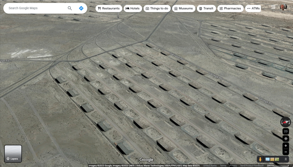
In deserts of rural, western Nevada, by the city of Hawthorne is the army depot. It’s where munitions are manufactured, but more importantly stored in these little isolated bunkers. Armies all over the world store munitions in similar fashion. I had believed that humidity might play into the life expectancy of munitions, and if that’s true, these bombs will be safe from corrosion for a very long time. Or perhaps the U.S government does not need to spend money on climate-controlled storage. The bunkers are equidistantly spaced, so that if there’s a mishap in one, it doesn’t cascade into all your weapons crates, burning up all your rockets, and making one giant crater.

These bunkers are concrete, with a concrete front, and sand is piled atop them. Native vegetation often grows over the bunkers, as we see in this image. What I find interesting in this site is that not only is each bunker serviced by a road, but the curving arcs toward the top of the image indicate rails. We can move weapons across the country by either transportation method.

Irrigating Grace, Idaho


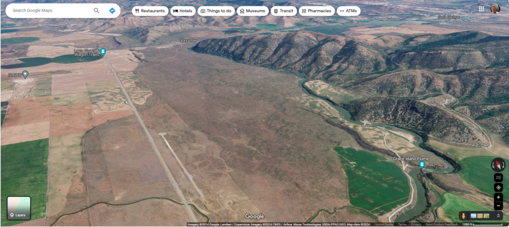
“Niter Ice Cave,” “Last Chance Canal,” and the town of “Grace” are all associated with Gem Valley on the Bear River in southern Idaho. The ice cave formed at the edge of a lava flow (I don’t know how–that’s not important right now,) Last Chance Canal refers to the desperate struggle to irrigate crops in the fertile valley before the land owner’s water rights expired, and “Grace” is the name of the Mormon community that flourished as a result.

In this fantastic image, the Bear River flows into Gem Valley from the top right corner, but instead of filling the valley with wholesome, hydrological goodness, the river appears to have been interrupted by a lava flow that fills the central third of the image. Crops on the left, mountains on the right, and igneous rock down the middle. And so, the water flows between the mountains and lava, doing nobody any good.

However, the height differential creates a unique opportunity for irrigation: if you can dig through old igneous formations carefully, you can irrigate the whole valley. The Last Chance Canal Company accomplished their goal, and added a bit of hydroelectric power into the deal as well. Last Chance Canal Historical Marker (hmdb.org)

The Palo Duro Canyon

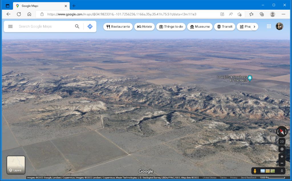
Screenshot of Google Maps looking northward over the rim of the Palo Duro Canyon

The high plains of Texas (or the Llano Estacado) are flat, semi-arid, and the view is not even broken by trees. But there is a really big ditch–the Palo Duro canyon.
How does such a landform impact the surrounding environment? There may be water flowing along a canyon floor, or pools of an ephemeral stream. If not, the water table is closer to the surface.

Either way, there is more vegetation, and a greater diversity of vegetation. The land may support trees that provide shade for mammals and nesting habitats for birds. Wildlife will congregate there for shelter and water.

It is where hunters find game and trappers find pelts.

Getting to the bottom of the Palo Duro canyon is not terribly difficult, nor is it as simple as walking to the supermarket but building a road through this terrain (and a bridge at the bottom) is expensive. Switchbacks will be involved, making the road longer, and still there will need to be accommodations–fill and culverts–for rough, sloping terrain and drainage.

Until a road is built through a canyon, commerce on either rim will be affected. Bulk transport will be unavailable.

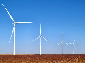
And let us not forget the wind. The bluebonnet is the state flower of Texas, but the wind turbine might as well be the state tree. At the bottom of the canyon there may not be much wind, but it will be a different experience on the rim.

Chutkotka Gulag

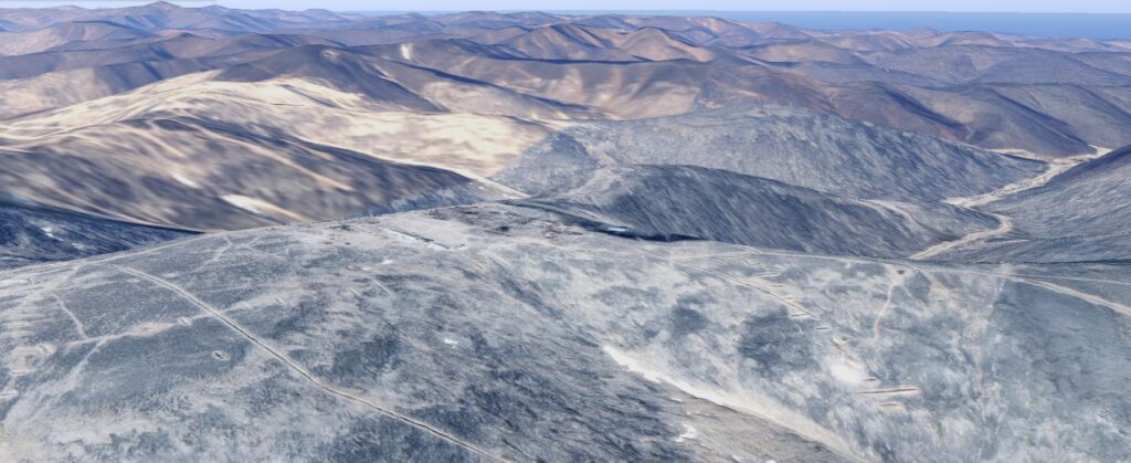
Paste these coordinates in Google Maps: 69.7405731, 171.8593084 Again, hold the shift key to tilt your view if you want, and be sure to expand the Explore imagery button at the bottom right.
Here we find a community built on a mountain above the arctic circle. There is no wood, no peat, no coal, oil, nor heat. But there is uranium in these hills, gold, tin, and other metals.

There’s really nothing good to say about this. Thousands of people died here, and for many reasons. One being that they were trying to survive in stone buildings built atop mountains in permafrost.
For more info, see Gulag of Chukotka, Russia (azattyk.org)

Tags: Government, Geology, Geography, I Have The High Ground Anakin

Lesotho: One country surrounded by another

I am addicted to maps.google.com. If you sign in, you can hold the shift key to tilt the map, giving you the ability to see elevation.

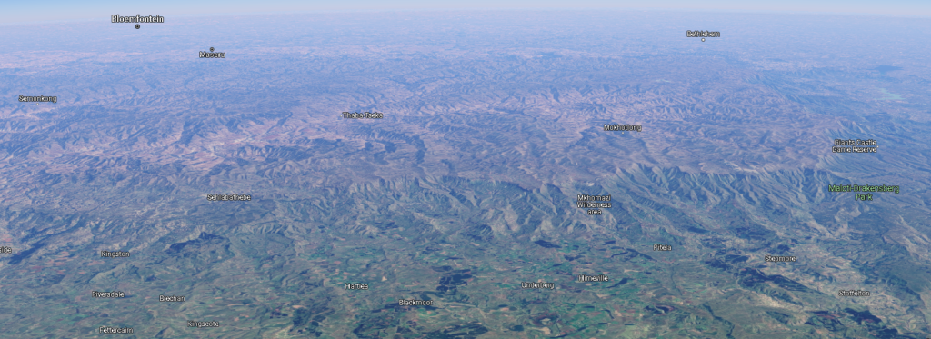
Here is an isometric aerial view of Lesotho; the boundaries are evident. It is set on a high plateau and carved with deep ravines. The tan and brown mountainous regions in the center and toward the back are Lesotho, and the green, relatively gentle terrain toward the front of the image is South Africa.

The oversimplified version: the people of Lesotho originally fled from the rising Zulu nation and defended themselves as the primary push of the Zulu was northward. Things stabilized somewhat until the French-supported Dutch (the Boer republic) on Lesotho’s doorstep encroached on their lands. A tussle ensued (Boer wars) and Lesotho emerged as a British protectorate (1868), and its own sovereign nation in 1966.

Tags: Geography, Geology, I Have The High Ground Anakin